When we tell people that we are planning on taking our boat from Lake Michigan to the Caribbean, one of the first questions is inevitably, “How are you going to get there?” To cruisers and people like us who having been dreaming about this voyage for over a decade, it seems like a silly question. That, of course, is because I’ve spent countless hours reading and researching the best options and making pro/con lists of the various possibilities. So for those of you who are interested, but don’t have the time or inclination to scour the web for the details, I’ll lay it out for you.
There are three primary paths from Lake Michigan to the Atlantic Ocean. (There are a few variations on these, but we will ignore that for the time being.) They are 1.) the Great Lakes to the NY State Canal System 2.) the Great Lakes to the St. Lawrence Seaway 3.) the river systems.
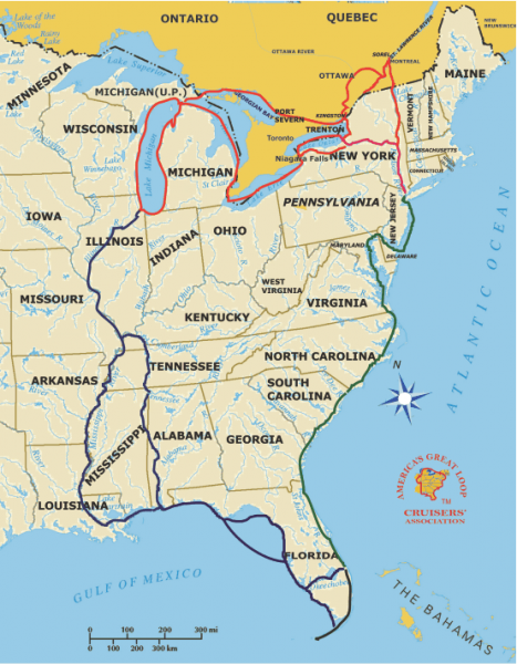
I’ll start at the end of that list to explain why we haven’t seriously considered the river system. From Lake Michigan, you can lock into the Calumet River or the Chicago Sanitary and Ship Canal, both of which meet up with the Des Plaines River, and then the Illinois River, which drops out into the Mississippi just north of St. Louis, MO. Once on the Mighty Mississippi, you have the choice to follow it to New Orleans which can be pretty isolating for a river, as there is a stretch of 449 miles of the river that has NO docks or fueling opportunities (“fuel, you say? I thought you were on a sailboat?”, I’ll get to that in a minute). The other option is to hang a left at Cairo, IL and head up the Ohio River to the Cumberland River which will take you to the Tennessee River, to Yellow Creek, to the Tennessee-Tombigbee Waterway (the Tenn-Tom). This route will eventually dump into Mobile Bay.
At the start of this 1,300 mile route, step one is take down anything that is higher than 19.7 feet above the water. For us that list is the mast. That means that we would be running the engine for the entirety of that section, and that’s not really what we’re about. With a maximum speed of 7.5 knots (nautical miles per hour) even at top speed, that would mean about 175 hours of driving though the rivers. This route is very popular with “Loopers” as it going with the flow and makes it much easier than trying to fight the current. “Loopers” are those adventurous souls who desire to cruise a loop around the eastern portion of the US. They take the route described above south, then make their way from the Gulf of Mexico, around (or through) Florida, up the East Coast and back “in” through one of the next methods I’ll describe to go “out”. There is a great resource for those who are interested http://www.greatloop.org/index.php .
The other two routes would start the same way for us. A long sail up Lake Michigan to Mackinac Island (for the record, Mackinaw City is the on the tip of the Lower Peninsula of Michigan and Mackinac Island is just out from there, but one is the French spelling and one is the British spelling and they are both pronounced Mack-i-naw). From there, it’s down Lake Huron where the St. Clair River, Lake St. Clair, and the Detroit River lead to Lake Erie. Cross Lake Erie where on the east end the final decision has to be made about the rest of the trip out. From here it is either follow the St. Lawrence Seaway, via the Welland canals (because the Niagra river takes a bit of a rough dip) and Lake Ontario to the St. Lawrence River, or enter the NY State Canal System and roughly follow I-90 from Buffalo to Albany, where you enter the Hudson River and follow it down past Manhattan to the Atlantic.
The St. Lawrence route is the route taken by commercial shipping traffic, which means that boats much larger than ours transit it on a regular basis. This is both a pro and a con in that, there is room for us to leave our mast up and sail a good portion of it, but it also means that there will be large slow to maneuver vessels along the way, that we will have to stay out of the way of. This route would take us up through Canada including Montreal and Quebec City and dump us into the Gulf of St. Lawrence, where weather permitting we could visit New Brunswick, PEI, Newfoundland and/or Nova Scotia. Our timing being what it will as late in the season as we may be departing though, I imagine that most of these places will be frigid and most of the inhabitants shifted to winter survival mode rather than entertain visitors mode. We would then have the entire East Coast of the US to explore.
If we opted for the NY state canals, we would have to take our mast down for that trip as well, but it would be for about a week as we make the 340ish mile journey across the Empire State. Another advantage of going East vs. South, is that it gives us plenty of options for the rest of the trip to the Caribbean. We could head offshore from the Gulf of St. Lawrence or NY and head directly there (or make a stop in Bermuda). We could also follow the Intracoastal Waterway down along the coast so we could visit friends along the way. We would still have the option, should weather permit, to take an “outside” run along the coast to get some salt air in the sails.
At this point, my inclination is to take the St. Lawrence Seaway. With the installation of AIS (more to come on that), we would have no trouble identifying, communicating with and avoiding commercial traffic. It would not require the removal of the mast, and the associated costs hassles with that. It would give us the opportunity to easily complete our first International leg into our friendly neighbor to the north. The real down side would be if we are forced to wait too late into the season, it gets very cold along that route and depending on how El Niño turns out this year, we may not want to deal with the temperatures.
The map included here is from http://www.greatloop.org/seasonal-great-loop-map-cms-1035 America’s Great Loop Cruiser’s Association also has some more great summaries of the various sections of the Loop http://www.greatloop.org/loop-segments-cms-1745 . You may notice that there is a “shortcut” from Lake Huron to the east end of Lake Ontario. That section includes the Trent Severn Canal across Canada. That path is not a real option for us, as our design draft (depth of the boat below the waterline) is 6 feet and there are sections of that system that have an operational depth of 1.8 meters (5.9 feet), so we would be a bit too deep to safely transit it. Not to mention the fact that we will likely have extra weight onboard with provisions and spares, so we may be a bit lower in the water than per the design. We would also have to drop the mast to clear bridges along that route as well. That does of course mean that we will not be eligible to take our boat for a train ride, at least not anywhere else in North America. Of course, if we end up in Scotland at some point, maybe we can take the boat for a Ferris wheel ride (just kidding, don’t think we’d fit through the rest of the canals).
The follow up to this question is always, “How long is that going to take?” and the answer to that one is more complicated. We will be at the mercy of the weather and our interest in places we stop along the way, but pushing straight through, my estimates are that going south would take a minimum of three and a half weeks, the NY canals route, at least two and a half weeks, and St. Lawrence three and a half weeks. The only real way to figure it out is for us to actually make the trip! We will inevitably make some stops along whatever route we take, so in any case, I am planning on a month or two after we leave before we reach salt water.